What is SIGAP?
SIGAP is a modern web-based platform designed to facilitate the monitoring and analysis of geospatial data related to well projects. This platform allows users to track real-time developments and field conditions through integrated maps and geographic information systems. Equipped with advanced analytics features, SIGAP helps decision-makers assess potential opportunities, risks, and operational optimizations efficiently and accurately. Additionally, its user-friendly interface and web accessibility enable easy access anytime and anywhere, supporting effective team collaboration and enhancing productivity and safety in managing well projects based on geospatial data.
Vision
The vision is to enhance operational decision-making through data-driven insights and spatial knowledge, enabling more informed, accurate, and efficient management of projects and resources.
Main Features
Geographic Information System Integration
Data Reporting Module (filter based on time, wells, production types)
Analytical Engine (charts, historical trends)
User Roles & Access Management
Workflow & Use Cases
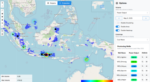
Monitor active wells
Operators and technicians can access a map display that shows all active wells in the A Area, which is color-coded based on production status. With a few clicks, users can view key metrics such as working hours, production volume, or warnings for each location, helping the team to get information without having to open many spreadsheets.
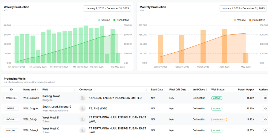
Create Monthly Production Reports
The reporting module allows analysis for filtering and exporting monthly production data based on location, well, or operator. Automatic graphs and summaries can be created for management presentations or for reviewing manual errors and ensuring data consistency.
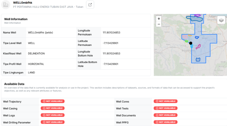
Data Barriers
Users can select wells directly from the interface, extract metadata, geospatial integration, and tabular data to ease spatial clearing and meet different system needs for re-evaluation.
Future Roadmap For SIGAP
Data Integration
Enhancing real-time data integration using sensors deployed in the field. This will enable SIGAP to automatically and quickly access the latest data, making decision-making more accurate and efficient.
Go Mobile
Developing a progressive web application (PWA) that allows users to access SIGAP features via mobile devices with a smooth and seamless experience. This makes it easier for field officers and users at other locations to manage data and monitor conditions directly from their devices.
Analysis
Focusing on predictive analysis to forecast reservoir performance and identify data trends. This helps in better planning and reduces risks of failure by understanding patterns from historical and current data.
AI/ML
Utilizing machine learning models to detect anomalies and perform advanced data analysis. This is expected to improve SIGAP’s ability to automatically identify issues, generate deeper and more accurate insights, and support smarter decision-making.